Rocky Mountain NP, CO – May, 2017
We entered the National Park during a driving rainstorm after a perfectly clear drive up from Lyons. Longs Peak was shrouded in several layers of gray, after appearing dauntingly above the foothills for most of the trip. Pyramidal with snow covering the top third, Longs Peak looks like a mountain a cartoonist would draw, and is normally the focal point of the park but today it seemed we would have to imagine its imposing presence. The welcome lodge was crowded with people waiting out the storm, most of which gathered around a bald, stern looking ranger who was sitting at a barstool at a table with a giant map. He explained to a young overpacked couple that beginning today the Trail Ridge Road was open past Many Parks Curve (9640 ft.) all the way to Rainbow Curve (10829 ft). They had done a good job clearing the snow pack, he said, and the whole road should be open in a couple of weeks. After this, the family behind them in line chimed in.
“How far can we drive up Trail Ridge Road?” said the husband. “All the way to Rainbow Curve” the ranger replied curtly.
“Aah, they must’ve done a good job clearing the snow pack. When will the whole road be open?”
“Couple weeks.”
I contemplated having this same conversation with the ranger but considering he’s probably answered these questions dozens of times today, I spared him. He was a more patient man than I, however, because if I were in his position I would respond by simply lowering my brow and pointing to the bold printed sign over his right shoulder that read Trail Ridge Road: Open to Rainbow Curve.
As soon as the rain stopped pounding against the lodge, Lauren and I went directly for Rainbow Curve, the highest point in the park that we could safely go without significant winter gear. Trail Ridge Road is the highest continuously paved road in the US, climbing the Rockies from Estes Park, past the treeline and into the alpine tundra to an apex of 12,183 ft before descending the other side into Grand Lake. It is only passable between Memorial Day and late September, and even then barely so due to the bottleneck traffic. With increase in elevation, the snow went from nonexistent to patchy, and once we past the 10,000 foot mark, at least a yard deep on either side of the road. We parked at Rainbow Curve in winds so strong I struggled to open the driver’s side door. An open topped tour bus was heading back down full of tightly bundled, uncomfortable looking people excited for the now sunny and 70 degree weather nearer to the park’s entrance. We looked around a bit at the curve before heading to lower, snowless elevations to do some hiking.
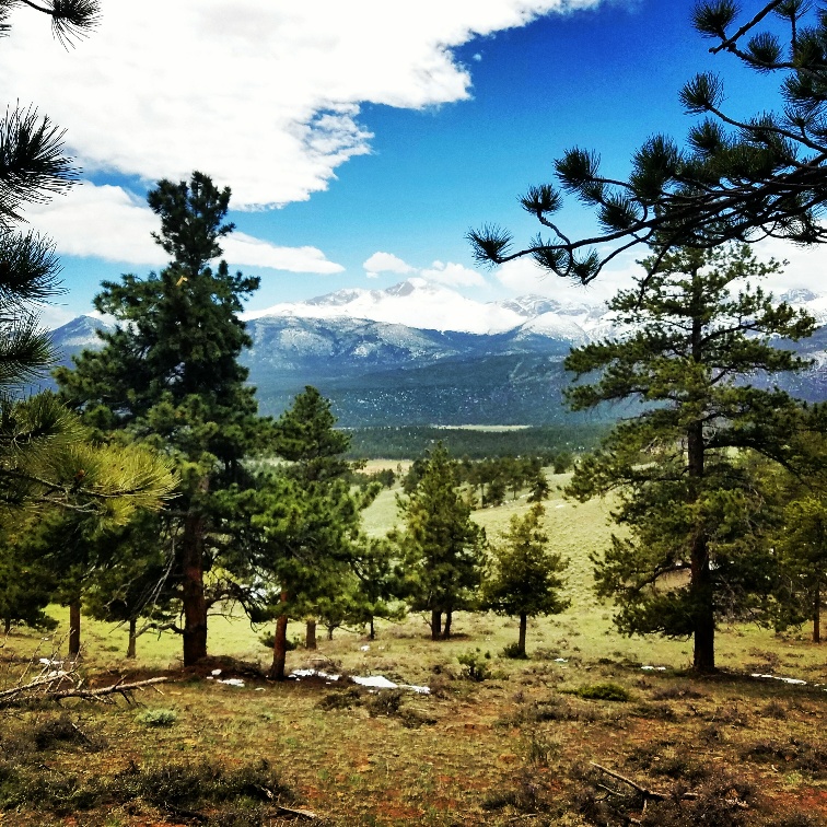
There were many more people at Many Parks Curve, and the conditions couldn’t have been more dissimilar despite only being 1200 feet downslope. The panorama is equally striking as well – pine forests and rock outcroppings framed by the high Mummy Range, the snowy peaks of which created their own cloud formations, whisking their way off of the summits into a partly sunny sky. These distant weather machines looked foreboding against the blue, looming in the background ready to generate an icy wind or an avalanche and fling it in any direction. Getting restless to find a trail, we drove back down from Trail Ridge Road and into the northern sections of the park.
Initially, we planned on hiking Hallett Peak via Dream Lake, one of the more fantastic hikes in the park with Alpine views and friendly pikas that climb into your backpack and dance around on the summit. At almost 13,000 feet, it is not quite a fourteener but is one of the more attainable day hikes in the park that gets you higher than the roads go. The remnants of the late-season blizzard stymied our plans to even get to Dream Lake, however, so our day in the park was to be spent spontaneously searching for a more grounded alternative.
Deer Mountain was apparently named after the wrong ungulate because not long after setting off from the trailhead, Lauren and I watched a herd of a half dozen elk enter stage left, first at a distance before nonchalantly wandering nearer. As long as we stayed perfectly still, they didn’t pay us any mind and instead munched on sagebrush or looked behind to see why the rest of the herd was taking so long. At one point they ambled within 30 feet of us and just kept moving, mowing the grass between the pines.
After the elks had made their slow crossing, we continued upward. The single-track dirt trail twisted slowly through a relatively open pine savanna with trees evenly spaced across a folding shrubby plain. The high peaks, like everywhere else in the park, provided a constant backdrop of ice and majesty. We passed a few solo hikers on their way down Deer Mountain, but it was otherwise devoid of sound.
About three miles into the trail I went up a side trail near a switchback to take some pictures. Lauren shouted something that was muffled in a suddenly steady wind. “What was that?” I called back, taking a few steps back down toward the main trail. “It’s about to rain again” she said slower, her voice carrying during a temporary calm in the increasing breeze. She pointed in the direction behind me and from her vantage point she could see a cobalt-colored storm cloud rolling down from the high peaks like a rapidly expanding cartoon snowball.
It caught us about a mile from the trailhead, lashing winds tougher than those we experienced at Rainbow Curve. Tiny raindrops shot from the same direction, hitting our faces as like a sandblaster. We huddled near a boulder as some of the smaller pine branches snapped above. A group of three guys who we crossed while hustling back some five minutes ago came barreling back in our direction, holding their jacket collars as makeshift hoods. They passed up the shelter in favor of a fervent dash to the car. By the time they would have made it, the clouds had cleared and their backpacks would have been dry as the intensity of the storm lasted no more than five minutes. The Mummy Range was once again visible to our left, the birds moved through the pine branches, and the chipmunks scurried through the bluebells as if it didn’t happen at all. My jacket, though never saturated, was fully dry in minutes allowing us some doubt as well.
We happened upon the Alluvial Fan by an act of stubbornness. Lauren and I were looking for Bear Lake and in my refusal to acknowledge that I misread the map I made decisions recklessly, ending up in a parking lot near a shack that looked like a tiny treehouse on wheels. I have no shortage of conceit when it comes to reading maps and I initially didn’t want to ask directions of the ranger who began walking from the shack in our direction.
“Are you looking for the sheep?” she asked.
“We’re trying to find Bear Lake,” my very patient wife answered and then we both inquired about the sheep.
“You’re nowhere near Bear Lake.” The ranger handed me a map identical to the one I was looking at, one finger where we were, fully on the wrong side of the center crease from where we wanted to be. “If you wait long enough here or head over to the Alluvial Fan you might see some sheep.”
We drove on to the Alluvial Fan because it was just down the road. It was formed in 1982 when a dam burst on Lawn Lake, some 1,000 feet above the valley, causing a flash flood so mighty that it drained the entire 48 acre lake in a half hour. The water carried with it massive chunks of mountainside, slowing down enough to spread out the sediment on the valley floor before continuing all the way into Estes Park. The resulting rock pile is strewn with several waterfalls and a fair bit of moderate climbing. An older man pointed to a grassy plateau above the first set of boulders as the area where the bighorn sheep congregate before clambering down the cliffs to follow the river. We climbed up with a few others and followed a secondary dirt path up the mountain towards what remained of Lawn Lake. Peering over the steep slope, the flat meadow that the old man pointed out was the only of its kind anywhere around, but was sadly sheepless. A few hundred more feet up was a spectacular panorama of the entire Mummy Range, a static world of snow and slopes that looked foreboding and impassible, and beyond that the aptly named Never Summer Mountains, a hazy and distant stage backdrop to the park. It left me breathless as if I were standing on one of the high peaks and we lingered a bit before checking for sheep again and driving to our final stop for the day.
Bear Lake Trailhead is where we would have started the Dream Lake to Hallett Peak hike if it were seasonally practical, but even the parking lot was covered in several feet of snow. We circled the lake on a trail that felt like a cross country skiing course, about ten feet wide and roller-coaster humpy with windblown snow. The lake itself was liquid and the temperature was well above freezing but the snowdrifts were so high from the previous week that they would likely last and delay even early June hikers a dry Hallett summiting. The beginning of the lakefront trail was crowded and children slipped down the mounds like characters in a Christmas cartoon but further away it was silent like the rest of the park, only broken by the wind and the haunted-house creaks of pine limbs rubbing together, our shoes through the slush adding a metronome. After two miles we had our fill of snow tramping and drove down to warmer altitudes.
On the way out we stopped for food and coffee in Estes Park. It is best known as the site of the Stanley Hotel, made famous in Steven King’s The Shining. The town itself appears to nearly match the amount of souvenir shops and general tourist fare of Boulder with significantly less in the way of population. Most visitors use it as a jumping off point to check off the National Park and it is typically overrun with out-of-state plates hanging off cars stuffed with children stuffed with Rocky Mountain taffy. This time of year though, it was still a sleepy mountain town ready to be shaken awake for summer. Another passing rainstorm cleared the streets further and we had a quick walk around town and a not so quick but filling meal at a bar that was empty other than ourselves. Our server told us that we were there on their first open day of the season and that Estes Park essentially turns into a western Gatlinburg from June to August. Despite the mercurial weather, I was glad we visited when we did to get a quick overview of the park. Next time, though, we have Hallett Peak in our sights.
